|
Reported Crop Circles for the State
of New York -
Medina / Shelby, Orleans County (July 5, 1991)
 
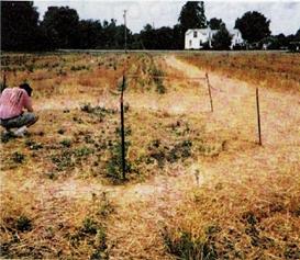
A 20' circle in wheat. The circle was swirled counter-clockwise, but out toward the edges radially. Further investigation showed that an underneath layer was swirled clockwise. The formation was located close to the Neuter Fort Native American burial site. A sighting of a BOL was witnessed the night before the circle discovery.
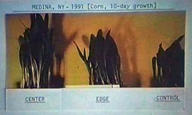
The circle was well-studied by W.C.Levengood who reported crystal changes in the seed heads of the plants, and showed accelerated growth rates in the plants which diminished the father from the center that samples were taken.
NEW INFORMATION COMING IN ON THIS FORMATION
CHECK BACK IN A FEW DAYS!!!
Crop type: Wheat
Source: W.C. Levengood, Pat Delgado
|
|
City
/ County / Date:
- [unknown]
(1927?)
- Conklin,
Broome County, NY
(June 16, 1964)
- Ithaca,
Thomkins County, NY (October 20, 1967)
- Gallupville, Schoharie County (August 5, 1968)
- [unknown] (1972)
- Freeport, Long Island (Big Crow Island), Nassau County (November
7, 1973)
- Annadale, Staten Island, Richmond County
(February 14, 1975)
- Farmingdale, Nassau County (September 30, 1989)
- Medina / Shelby, Orleans County (July 5, 1991)
- [unknown], (July 17, 1991)
- [unknown], Herkimer County
(July 26, 1992)
- Vickerman Hill, Columbia Center / Herkimer / Mohawk Valley,
Herkimer County (July 21, 1993)
- [unknown], Oneida County (November 1993)
- Vienna / Oneida Lake, Oneida County (August 14, 1994)
- Schodack, Rensselaer County (August 23, 1994)
- Marion, Wayne County
(August 11, 1997)
- Marion, Wayne County
(October 21, 1999)
- Weedsport, Cayuga County
(July 19, 2001)
- Fremont, Sullivan County (September 2001)
- [unknown], Steuben County (September 2001)
- Amherst, Erie County
(July 31, 2002)
- [unknown], Steuben County (August 9, 2002)
- Saratoga Springs, Saratoga County (June 12, 2003)
- Canisteo, Steuben County
(August 12, 2005)
- Mendon, Monroe County
(October 14, 2005)
|